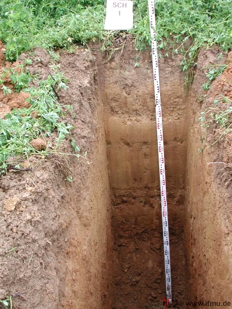
A JCB 3CX backhoe loader positions its extendable dipper arm over the staked-out point, and within forty-five minutes a rectangular excavation reaches 3.5 metres through the weathered London Clay that underlies much of the Basildon area. The exploratory test pit exposes a continuous vertical profile: topsoil over stiff brown clay, a thin band of gravel at two metres, and then the blue-grey intact clay beneath. In Basildon, where the town expanded rapidly across the Thames terrace deposits during the post-war new town development, these direct observations provide data that borehole logs alone cannot capture. The exposed face allows the engineering geologist to measure discontinuity spacing, identify shear surfaces from past desiccation, and extract undisturbed block samples for laboratory strength testing. Combining the visual record with in-situ permeability tests run at discrete horizons inside the pit gives a complete picture of drainage behaviour before foundation placement.
A single test pit wall in Basildon reveals more about the soil structure than ten borehole logs, especially where the London Clay transitions into the overlying Claygate Member.
Methodology applied in Basildon
Risks and considerations in Basildon
Basildon was designated a new town in 1949 to absorb London overspill, and the construction boom that followed transformed farmland and plotlands into residential estates and industrial areas across the borough. Some of the earlier developments, particularly around Vange and Pitsea, were built on made ground that was never properly characterised before construction. Old brickearth pits, backfilled gravel workings, and unrecorded landfill cells exist beneath what now look like ordinary residential streets. An exploratory test pit is the most direct way to identify these buried features: the pit wall shows the contact between natural and made ground, the presence of brick fragments or ash, and the depth of disturbance. Without this visual evidence, a standard borehole log might misclassify a three-metre thickness of reworked material as natural drift, leading to a foundation design that underestimates differential settlement risk. The pit also allows the engineer to smell the soil; hydrocarbon contamination from former industrial use in parts of the town is still detectable decades later.
Our services
The trial pit investigation in Basildon is augmented by supplementary field and laboratory services that transform a visual profile into a comprehensive geotechnical dataset.
In-Situ Strength and Permeability Testing
Once the pit is open and logged, we perform hand shear vane tests on cohesive soils and infiltration rate measurements within the pit floor. These readings provide undrained shear strength profiles and permeability coefficients that feed directly into bearing capacity and drainage calculations.
Laboratory Classification Suite
Samples collected from each stratum inside the pit are delivered to our UKAS-accredited laboratory for moisture content, Atterberg limits, particle size distribution, and, where required, quick undrained triaxial testing. The full classification report is cross-referenced with the field log for a consistent ground model.
Common questions
What depth can an exploratory test pit reach in Basildon's ground conditions?
With a standard 3CX backhoe on firm London Clay, pits typically reach 3.5 to 4.0 metres. If the Claygate Member sands are encountered, the pit may need to stop shallower or be battered back for stability. For depths beyond 4.5 metres, or where groundwater is high near the Crouch and Thames corridors, a supported excavation or borehole may be more appropriate.
How long does the local council take to approve a trial pit on private land in Basildon?
For standard residential or commercial plots within the Basildon borough, the team handles the utility search and obtains the permit from Essex Highways if the pit is near the public highway. Private land investigations with no road opening usually proceed within a week of instruction; the council's building control department does not typically require separate approval for exploratory pits that are backfilled the same day.
What does an exploratory test pit cost in the Basildon area?
For a standard investigation with one or two pits on a residential plot in Basildon, the cost ranges from £350 to £660, depending on the number of pits, depth, and whether laboratory testing is included. A site with restricted access or the need for a traffic management plan will be at the upper end of this range.
Can a test pit replace a borehole for a house extension in Basildon?
In many cases on the stiff London Clay that underlies much of Basildon, a well-executed test pit to 3.5 metres, combined with laboratory classification, provides sufficient information for a standard strip footing design. If the extension is near a tree line or on the more variable Claygate Member, the building control officer may request a borehole with SPT testing to confirm the bearing stratum at greater depth.